Pages

Thursday 29 January 2015

Lake District Wild Camp 21-22/1/15

After setting off at silly o' clock I arrived in Nether Wasdale just after 7am to a slightly overcast sky with the wind hustling the clouds along at a decent pace.
I clicked my head torch on and set off along the road in the direction of Wastwater.
Instead of going straight into the ascent I decided to take a quick stroll around Low Wood at the end of Wastwater for some photo's.


The occasional Squirrel made for higher ground as I passed through their quiet surroundings.

Looking over Wastwater towards Yewbarrow.
After taking a few shots I packed my camera gear away and set off back through the woods.


I stopped to collect some water from the River Irt (Wastwater's outflow) as I wasn't sure if I'd pass any sources on my climb up to Whin Rigg.
I headed Southeast to the path that ran beside Greathall Gill.


The going was quite steep and the ground was quite solid, luckily not too icy so it provided secure footing.


As I got onto the main path I stopped for a quick brew, the initial climb had been thirsty work!
The only interruption was the occasional bang from the Eskmeals range.
I hadn't seen a single person yet, but I expected that would soon change as I headed along the ridge.

Cairn leading to Whin Rigg.
The ascent relaxed a little as I made my way to the Summit of Whin Rigg with occasional bursts of sunshine lighting up the tops of distant fells.

View down the Great Gully.
After a quick tap of the Whin Rigg summit cairn I set off across the top towards Illgill Head, the path had very little elevation change so would be a fairly easy stroll.
The snow was ankle deep in places and there was a nice fresh breeze blowing.

Looking towards Illgill Head.
After a quick detour to photograph a frozen pool I continued on my way with a slight uphill gradient ahead of me.


Looking back to Whin Rigg.
Some of the biggies at the far end of Wastwater loomed into view as I neared the end of Illgill Head.

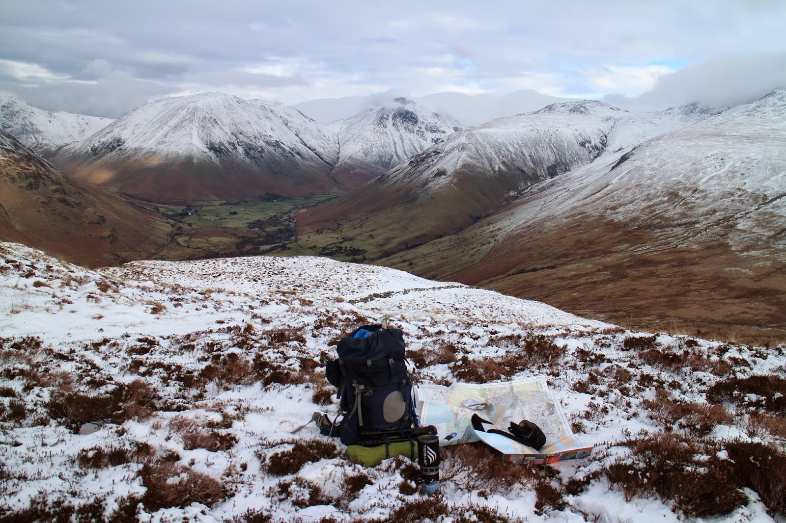
Yewbarrow, Kirk Fell, Great Gable and Lingmell.
It was 2pm and I'd walked for about 6 hours (and the surrounding views were cracking) so I decided a lunch stop was needed.
The sun made a brief appearance as I was tucking into my ravioli in tomato sauce!

Lunch stop with superb views.
I set off to make my descent, my aim being to camp somewhere near Burnmoor Tarn.
A party of 6 or 7 people far below were making there way towards Burnmoor Tarn, I hoped they weren't intending to stay the night.

Sca Fell.
Once I got beyond the snowy end of Illgill Head the route down to Burnmoor Tarn was very boggy and the tussocky grass made progress very slow.
As I got nearer it became apparent that I couldn't pitch anywhere near here.
I filled up my reservoir at a fast flowing stream and headed Northeast and after a tiring 2km search I finally found a raised area well away from the main path that was ideal for my nights stop.

Burnmoor Tarn with Burnmoor Lodge directly behind.
Force 10 Ion 2 with Burnmoor Tarn in the background.
After a few shots of my tranquil surroundings I headed indoors for a coffee and evening meal.

The view out to Yewbarrow.
The nice dusky light provided one last photo opportunity before I headed indoors to bed, it had been a long day and I slept soundly.


I awoke to a much brighter day with frequent sunny outbursts, for some reason it took ages to break camp.

Morning sunlight on Illgill Head.
I headed directly for Sca Fell, the path had a gentle initial gradient and conditions were ideal.


Sca Fell.

Ice cold and super fresh!
I could hear a stream burbling below so I began chipping away at the ice to get to the flowing fresh water, it was worth the effort and I took a few gulps before continuing on my way.

Illgill Head from my ascent of Sca Fell.
The ascent was extremely gentle and I slowly rose above some of the lower peaks that surrounded me.


As I got ever closer to the top, the ground became much steeper and very rocky, the ice axe had begun earning its keep!

Getting close to the summit of Sca Fell.
I got to within 100 metres (vertically) of the summit but due to worsening conditions and limited routes down and I decided to turn back.

Low cloud closing in while descending Sca Fell.
As I retraced my steps I had to think of another place to stop overnight as my other one was on the descent of Sca Fell.
The sun and clouds were creating a special scene in front on me and I picked up the pace.


Fantastic lighting effect behind Burnmoor Tarn.

My initial plan was to pitch up somewhere near the end of Illgill Head but the ground yet again proved to be too waterlogged and in fairly close proximity to the path.


I descended further with my only remaining option being to pitch on the shore of Wastwater (or somewhere close nearby).
The orange sky hinted at a missed sunset opportunity and I plodded on.


As I walked by the rocky shore of Wastwater I noticed some litter had been washed up, after some cursing I picked it up, only to notice it was full and still sealed!

Kirk Fell and Great Gable over Wastwater.
As I continued my stroll on the shoreline the map showed one spot left to pitch before the grassy areas disappeared altogether.


As I rounded the corner of my last opportunity to pitch, the sun was setting beautifully over Wastwater (I should have checked my watch before writing it off earlier!).
I couldn't believe my luck! I slung the pack off and began shooting and switching lenses like my life depended on it!


After my sunset photo binge it was time to tackle the pitching of the tent.
It wasn't easy as I had minimal space, the ground was strewn with half buried rocks, the pegs would only insert 1/4 of the way and it was on a bit of a slope.

Ion 2 pitched on very rough ground.
It was far from a perfect pitch but it would do for the night.
The sky was overcast and I headed indoors for an evening meal with some Skittles for afters!

My litter picking reward!
Despite two hours trying to nod off, I was still awake and peered out of the tent to see if conditions had improved, to my surprise they had and I quickly got dressed and grabbed my gear.
Cloud was patchy and stars twinkled through the gaps, I was out there for a good 45 minutes before retreating back inside the tent.

Wastwater in darkness.

I slept well and woke early to the pattering of light rain on the flysheet.
The weather had closed in as forecast and I made my way Southwest along the Wastwater shoreline.


Even though I only had 3km to cover, the journey was soul destroying.
The slippery rocks and giant boulders meant safe progress had to be made at a snail's pace, Yewbarrow and Middle Fell seemed to take a lifetime to pass on the opposite shore.


As I neared the end of the shore, the rain started and soon enough a torrent was soon falling from up above.


My waterproofs were cinched up and I happily left the sapping scree behind as I made my way slowly towards Easthwaite.
The last couple of kilometres were a struggle and I finally began to home in on The Strands Inn.
After a quick change I headed inside to dry off in front of the log fire and for some much needed hot food and refreshment!
Hopefully my next trip won't be so long away as I've got a lot of things on my to-do list :)

Sunday 4 January 2015

Glyders Wild Camp 30/12/14

Route: Glyder Fach-Glyder Fawr
Map of route: http://gb.mapometer.com/walking/route_4011393.html

It was still dark when I parked up and I had half an hour or so to kill before I set off.
As my eyes adjusted to the slowly brightening landscape, the size of the peaks that surrounded me took me by surprise, monstrous hulks of rock in every direction each with a healthy sprinkling of snow.
As the time reached 8 o' clock I donned my gear and set off South over the ladder stile.

Looking West towards Foel Goch.
After a few pictures and an uneventful stream crossing I carried on in the direction of Llyn Bochlwyd, the terrain was boggy and often required a slight change of course to avoid the worst of it.


The dinosaur backed hulk of Tryfan.
The going soon got easier as I joined the main path that ran beside Nant Bochlwyd, though patches of snow were becoming more frequent.


Pen yr Ole Wen in the background.
The path soon steepened to a scramble and handholds were needed due to ice and snow making the path extra challenging, I decided the Yaktrax would be put on as soon as I had reached level ground.


After a fairly short and steep climb I reached the absolutely stunning Llyn Bochlwyd with Glyder Fach making a fantastic backdrop, it seemed a hell of a reward for such a short walk but I wasn't complaining!
After putting the Yaktrax on and taking a quick photograph for a couple nearby, I headed Southeast towards Bwlch Tryfan.

Llyn Bochlwyd below Glyder Fach.

Despite cruising past the 550m mark, the ascent was effortless, the views were increasingly amazing and it was still early in the day, I couldn't have been happier!

Leaving the gorgeous Llyn Bochlwyd behind.
As progress was good I decided a quick coffee break was needed and the Jetboil was promptly fired up.
After a quick slurp while taking in the epic views and watching a few people make their way up, I packed up and carried on.

Brew time (at approx 650m).
As I crossed the ladder stile at Bwlch Tryfan I joined the Miner's Track which had a slight downhill section and offered extensive views to the North and East which were fantastic.

Looking up to Glyder Fach.

Some climbers taking a more direct route up.
Soon enough the path was rising steeply upwards as I made my way towards the crossroads.
I'd originally planned to camp somewhere near here but I was well ahead of time so decided to go with my second option.


Looking East towards Y Foel Goch.
Soon after turning West the going began to get tougher and my calf muscles finally felt like they were at 800m!
I was surprised at the amount of people on their way up Glyder Fach (given the conditions) and stopped briefly for a snack a little way from the main path.

Tryfan (left).
I reached the summit just after lunchtime and decided to plod on, I chatted with a couple of people about camping and the weather, then continued to head West towards my next port of call (Glyder Fawr).

Looking down on Llyn Bochlwyd.
Castell y Gwynt.
On route to Glyder Fawr the weather closed in a little and I ended up a fair bit South of where I should have been.
A 'short cut' caused me even more grief as I battled with waist deep snow and soaked both of my feet in a hidden stream, I retraced my steps feeling frustrated and tired with the added pressure that there was only and hour and a half of daylight left.
After a knackering trudge I was extremely relieved to see the fence on Y Garn, all that remained was the steep descent down to my planned camping spot at Llyn y Cwn.

A bit of mist rolling in.
My original pitching location was on the pebbly shore of Llyn y Cwn but I was unable to get the pegs in far enough and the wind promptly ripped them out.
After a quick scout round I found a better spot to pitch, unfortunately it was more exposed to the wind and required a few pegs in before the poles were inserted.
I was thankful to have my shelter up just before nightfall and quickly inflated my sleeping mat to give some insulation from the freezing ground.

Force 10 Ion 2 pitched by the beautiful Llyn y Cwn.

After taking off my sodden boots and clothing I got into my sleeping bag and cracked on with some hot food and a drink.


After broken sleep of two hour intervals (due to the unrelenting wind all night long) I had a quick breakfast and departed just as it was starting to get light, my headtorch and flashlight lighting up the way ahead.
The route down the Devil's Kitchen was treacherous and thankfully the steep and slippery bit didn't take too long to safely navigate.

Llyn Idwal with Pen yr Ole Wen rising up behind.
On my slow stroll down to Llyn Idwal I passed a couple of people on their way up the Devil's Kitchen.
An impressive collection of small waterfalls got my attention and I ditched my pack to get the tripod and wide angle lens out.


The path leading to the Devil's Kitchen.
As I got to the far end of Llyn Idwal I tried to be creative (as the ever increasing wind was whipping up some impressive waves) unfortunately the wind was so strong that all I achieved was to get spray on the camera lens!
As I took the final path back to the car I passed a multitude of groups on their way up, it surprised me a little as the weather was suppose to be closing in.

Looking back at Glyder Fawr and the Devil's Kitchen.


Despite a minor hiccup with my navigating, I'd ended 2014 on a huge high, Wales had well and truly blown my mind and I look forward to exploring it further in the not so distant future.
I'd also like to wish my blog readers and Twitterers a Happy New Year, see you on the hills! :-)